-
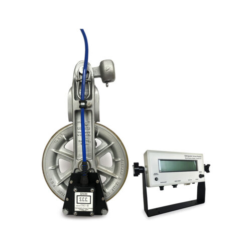 HSP 22" Sheave Counter Comes with remote display, accessory kit, 100-ft deck cable, and reusable transit case.
 -
 Trimble RTX® represents a family of GNSS correction services that provide customers with high-accuracy positioning via Satellite or the Internet. While stand-alone GNSS positioning without corrections provide horizontal accuracies that are typically more than 1 meter, Trimble RTX correction services can provide horizontal accuracies better than 2 cm. CenterPoint® RTX correction service is a flagship product of the Trimble RTX product portfolio. CenterPoint® RTX Marine is a real-time correction service, using an absolute positioning technique to model and correct GNSS biases, including clock errors, satellite orbit errors, and atmospheric delays, for construction and geospatial applications in the Marine sector.
 -
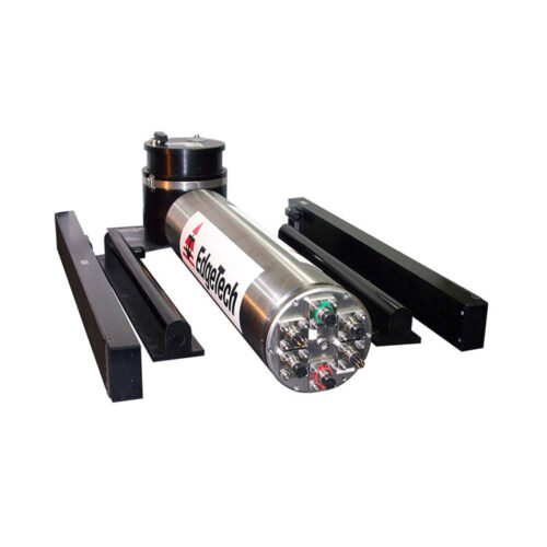
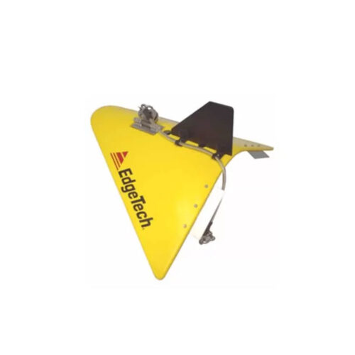 EdgeTech 4125i Depressor Wing Kit 18" V-wing Depressor Tow Key, Center Support Mount, Tow Point Hinge, Shear Pin, Cable Clip
 -
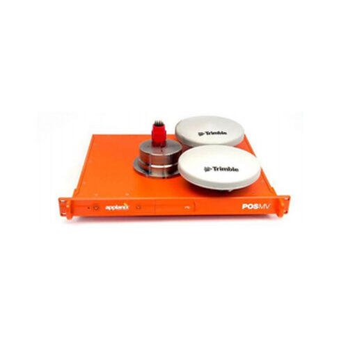
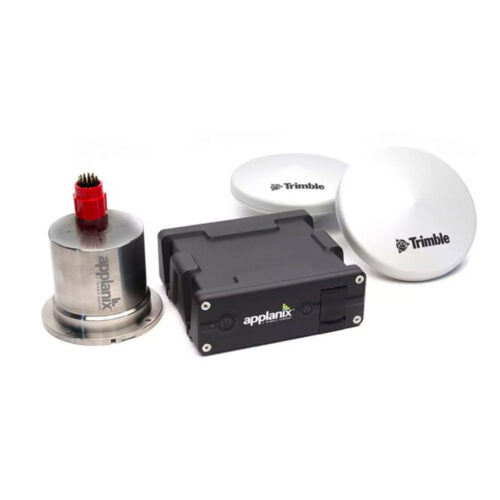
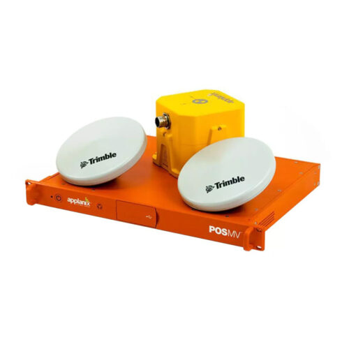 Maximize your ROI with Applanix® POS MV WaveMaster. WaveMaster is a user friendly, turnkey system designed and built to provide accurate attitude, heading, heave, position, and velocity data of your marine vessel and onboard sensors. Applanix POS MV blends GNSS data with angular rate and acceleration data from an IMU and heading from GNSS Azimuth Measurement System (GAMS) to produce a robust and accurate full six degrees of freedom Position and Orientation solution. All Applanix POS MV models are designed for use with multibeam sonar systems, enabling adherence to IHO (International Hydrographic Survey) standards on sonar swath widths of greater than ± 75 degrees under all dynamic conditions.
 -
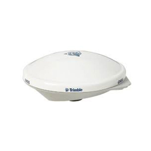 Applanix GNSS antenna, 540AP
 -
 Innomar Medium-100 Parametric Sub-Bottom Profiler Equipment rental to supply an Innomar Medium-100 Sub-Bottom Profiler. Comes with topside interface with built-in PC, pole mountable transducer with 30-meter deck cable, accessory kit, SES-WIN control software, mounting hardware, and transit cases.
 -
 Kongsberg EM 2040 MKII Multibeam Echosounder The EM 2040 MKII is a true wideband high-resolution shallow water multibeam echo sounder, an ideal tool for any high-resolution mapping and inspection application. With this release, Kongsberg Discovery has upgraded the hardware and software to increase the swath and improve the data quality of our EM2040 series.
 -
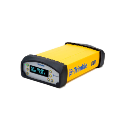 Trimble SPS851 DGPS Receiver Equipment rental to supply an Applanix POS MV OceanMaster RM IP68. Comes with a deck mount inertial measurement unit (IMU), rackmount topside interface box, dual GNSS antennas, dual antenna cables, interface cables, software, user manual, and transit case.
 -
 EdgeTech 3100P Sub-Bottom Profiler (4-24 kHz) Equipment rental to supply a towed 4-24 kHz chirp based sub-bottom profiler. Comes with topside interface, 35-meter tow cable, acquisition laptop preconfigured with EdgeTech's Discover control software, and transit cases.
 -
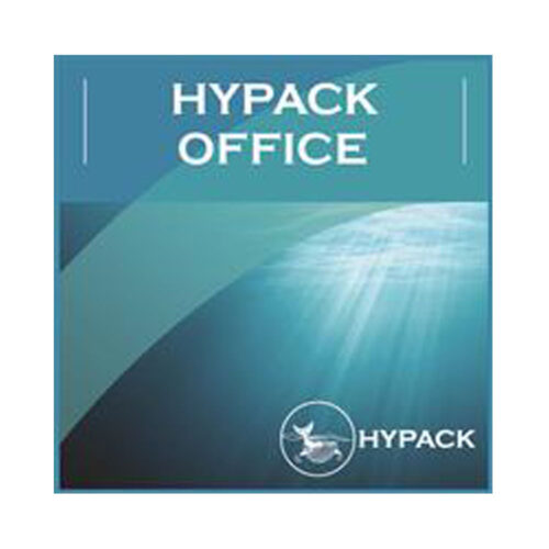 HYPACK OFFICE & HYSWEEP OFFICE HYPACK OFFICE & HYSWEEP OFFICE: The OFFICE COMBO is recommended for planning, editing and generating final products from anytype of survey data collected using the MAX or HYSWEEP modules.
 -
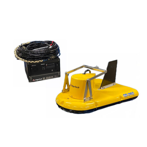
- Option for integrated OEM Inertial Navigation System
- 4th generation MPES (Multi-Phase) technology
- Co-registered simultaneous dual frequency side scan data
- Bathymetry data which is IHO SP-44 Special Order compliant
- Gap-fill side scan sonar and bathymetry data
- Bathymetry backscatter data
- Motion Tolerant side scan data
- Swath sectors of up to 200° means far shorter time for data collection
- Optimized Bathymetry modes: Equidistant and Equiangular
- EdgeTech’s Discover Bathymetric control software
- Integrated sound velocity sensor
- Unrivaled swath coverage and resolution in shallow water when compared to other MBES or PDBS sonar.
-
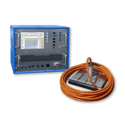
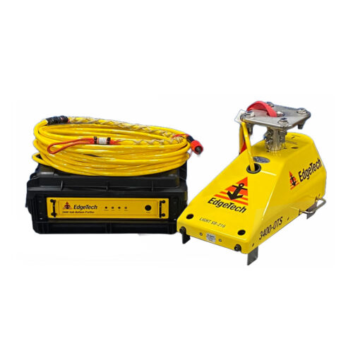
 EdgeTech 3400-OTS Low Frequency Pole-Mount Sub-Bottom Profiler (1-10 kHz) & 4 kW Amplifier Consisting of part numbers: SS-6e / 0021312 / 0022762 3400 Topside Processor with 4KW Amplifier and Rackmount PC pre-installed with Discover SBP Acquisition & Display software, Keyboard, Trackball, 24" LCD Monitor 3400-OTS Low Frequency Digital Profiler with Dual 1-10 kHz Chirp Transmitters Large Receiver Array Stainless Steel Frame for installation on client supplied Pole Motion, Depth & Heave Sensors Dual Frequency Transmission, User selectable Pulses 50m Kevlar Reinforced Multiconductor (1.47cm/0.58?) Tow Cable
 -
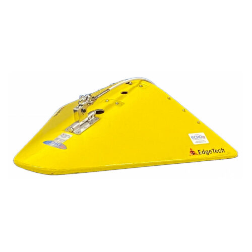
 EdgeTech 3400-OTS Lightweight Sonar Head (2-16 kHz) 3400 Topside Processor in 2U case Splashproof Laptop Computer with Sunlight Readable Display and DISCOVER SBP Software Topside configured for use with a 3400 OTS Light (2-16 kHz) sonar head
 -
 EdgeTech 2 Foot Depressor Wing Kit for 4205 Series Towfish 2-foot V-Wing Depressor Tow Key, Center Support Mount, Tow Point Hinge, Shear Pin, Cable Clip
 -
 Maximize your ROI with Applanix® POS MV SurfMaster. SurfMaster is a user friendly, turnkey system designed and built to provide accurate attitude, heading, heave, position, and velocity data of your marine vessel and onboard sensors. Applanix POS MV blends GNSS data with angular rate and acceleration data from an IMU and heading from GNSS Azimuth Measurement System (GAMS) to produce a robust and accurate full six degrees of freedom Position and Orientation solution. All Applanix POS MV models are designed for use with multibeam sonar systems, enabling adherence to IHO (International Hydrographic Survey) standards on sonar swath widths of greater than ± 75 degrees under all dynamic conditions.
 -
 Fugro MarineStar Subscription available with the following options:
- Fugro MarineStar, Monthly, Coastal
- Fugro MarineStar, Monthly, Regional
- Fugro MarineStar, Yearly, Coastal
- Fugro MarineStar, Yearly, Coastal Inland
- Fugro MarineStar, Yearly, Regional
- Fugro MarineStar,Monthly, Coastal Inland
-
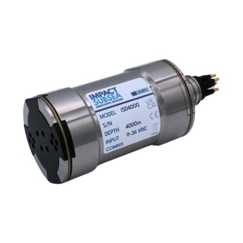 Impact Subsea ISD4000 Depth Sensor Equipment to supply an Underwater depth (pressure) and temperature sensor with titanium housing and integrated AHRS (roll, pitch, heading sensor). Comes with 0.5-meter interface whip, USB drive with SeaView configuration software and user manual, quick start guide, and transit case. Pressure rating: 300dBar
 -
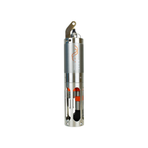 The AML-3 LGR CTDSV 6000m is an all inclusive package built around the AML-3 Logger with Conductivity-Temperature, Sound Velocity, & Pressure (1000 dBar). Comes with charging cable, power adapters, USB WiFi adapter, rubber weight lines, USB drive containing software and manuals, and transit case.
 -
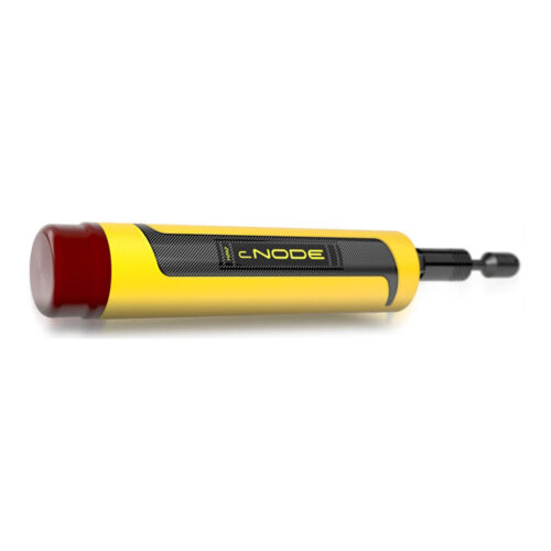 Kongsberg cNODE Micro 31-180 Beacon Equipment rental to supply a cNODE? Micro transponder. Small and light enough to be used by divers and shallow water ROV's. Comes with pressure sensor rated to 600m, charging kit and transit case.
 -
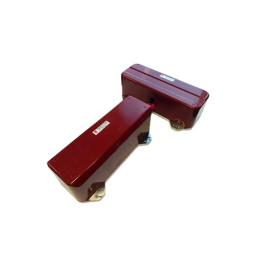
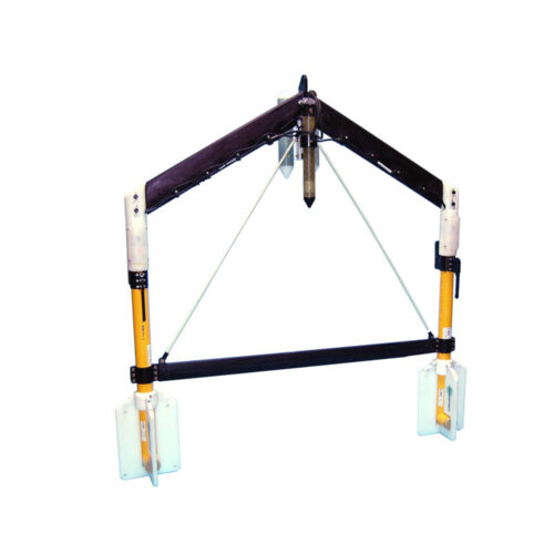 G882 TVG Transverse Gradiometer Equipment rental to supply a fiberglass transverse wing and two G882 cesium vapor magnetometers, altimeter, and depth (pressure) sensor supplied with 60V Deck Power Supply Junction box, 150-meters of soft tow cable, tool kit, serial cable, USB-to-Serial adapter, power supply, USB drive with Geometrics configuration software and user manuals, and transit cases.
 -
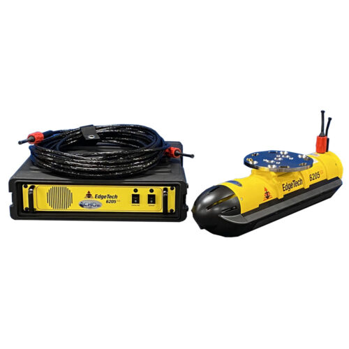
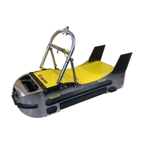 Equipment rental to supply a towed EdgeTech 2300B Tri-Frequency Side Scan Sonar 230/540/850 KHZ with 540 KHZ 3D Bathy & High-Resolution Sub-Bottom Profiler Towfish System fully integrated with a Rovins 3000 Inertial Navigation System to include USBL positioning, and depth sensor.
 -
 EdgeTech 2205 Tri-Frequency SSS & 2-16 SBP (ROV) 2k Depth Rating Equipment rental to supply a Combined EdgeTech 2205 SS & SBP System designed for ROVs and AUVs. Comes with bottle electronics, side scan sonar arrays, sub-bottom transducer and PVDF receiver arrays, Discover software, and mounting brackets.
 -
 Applanix POS MV WaveMaster II (220) Equipment rental to supply an Applanix POS MV WaveMaster SFF IP68. Comes with a submersible inertial measurement unit (IP68 IMU), small form factor (SFF) topside interface box, dual GNSS antennas, dual antenna cables, interface cables, software, user manual, and transit case.
 -
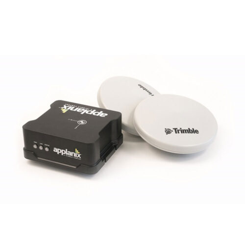 Applanix POS MV SurfMaster One Equipment rental to supply an Applanix POS MV SurfMaster One. Comes in a all-in-one IMU/PCS small form factor topside, dual GNSS antennas, dual antenna cables, interface cables, software, user manual, and transit case.
Contact us at +1 (706) 522-3022
TOP NEWS!
481 S. Jackson Street
Hartwell, GA 30643
Shop
Your account
Stay Connected
Explore the latest updates, product releases, and subsea technology insights from ECHO81.