Sales

  • Overview

    • Processing of all Innomar data formats, including SES3 files.
    • Handling of 16/24/32-bit and multi-channel data files.
    • Similar "look'n'feel" as the Innomar SESWIN on-line control and data acquisition software.
    • Intuitive handling of 2D data sections with free zoom levels and undo/redo.
    • Project-based workflow, but can also be used to view/process single data files.
    • Integrated GIS-browser builds the file handling base.
    • GIS map synchronized with seismic section view (cursor, track cross-points, picked targets and ground-truth positions).
    • Processed and interpreted data can be exported into various industry-standard data formats, including ASCII, DXF, 3D grids.
  • USM Compact OTS Pole Mount Equipment rental to supply a USM Compact Over-the-Side (OTS) Pole Mount System. Comes with Compact base with shear block assembly, 5-ft x 3.5-in Z-pole, storage angle bracket, 3-ft cheater bar, and mounting hardware. **Weld down plate sold separately and is a consumable item as it will be permanently affixed to the vessel. **VOOP kit may also be used for non permanent installations
  • The Compact Vessel of Opportunity kit is everything you need to add a Compact Sonar Mount to your vessel without the need to weld onto or drill through your gunnel. The VOOP kit can be configured in endless ways, using various extensions, supports and clamps.
  • Kongsberg 352P MGC R3 USBL System Portable system designed for tracking ROV's, towfish, divers and other subsea objects at several thousand meters range. The system operates in SSBL mode where it measures the distance and direction to subsea transponders and computes a 3D position in local coordinates or in geographical coordinates. Built-in MGC RT inertial measurement unit for roll/pitch and heading compensation. No need for calibration to determine roll, pitch and heading alignments.
  • Kongsberg EM 712 Multibeam Echosounder The EM 712 multibeam echo sounder is a high to very high-resolution seabed mapping system capable of meeting all relevant survey standards. The minimum acquisition depth is from less than 3 m below its transducers, to a maximum of 3600m dependent upon array size. Across track coverage (swath width) is up to 5.5 times water depth, with a maximum of up to 4400 m, which is almost double the range performance of the EM710.
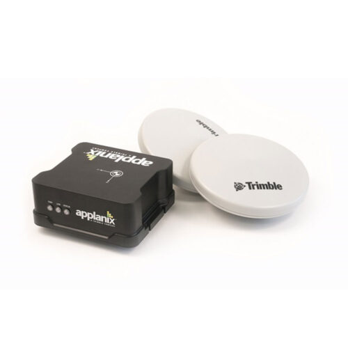
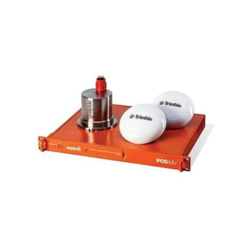
  • Maximize your ROI with Applanix® POS MV SurfMaster. SurfMaster is a user‑friendly, turnkey system designed and built to provide accurate attitude, heading, heave, position, and velocity data of your marine vessel and onboard sensors. Applanix POS MV blends GNSS data with angular rate and acceleration data from an IMU and heading from GNSS Azimuth Measurement System (GAMS) to produce a robust and accurate full six degrees of freedom Position and Orientation solution. All Applanix POS MV models are designed for use with multibeam sonar systems, enabling adherence to IHO (International Hydrographic Survey) standards on sonar swath widths of greater than ± 75 degrees under all dynamic conditions.
  • EdgeTech 4205 Depressor Wing Comes with stabilizing fin, depressor tow key, safety cable, mounting hardware, and installation guide.
  • Impact Subsea ISM3D Motion Sensor, Titanium 6k Rated Equipment to supply Underwater Attitude and Heading Reference System (AHRS) with Titanium or Acetal housing and selectable Inertial Mode. Comes with 0.5-meter interface whip, USB drive with SeaView configuration software and user manual, quick start guide, and transit case.
  • Impact Subsea ISS360 Compact Imaging Sonar Equipment to supply a small and portable Compact Imaging scanning sonar system. Comes with a titanium instrument, 0.5-meter interface whip, USB drive with SeaView configuration software and user manual, quick start guide, and transit case.
  • Overview

    • Processing of all Innomar data formats, including SES3 files.
    • Handling of 16/24/32-bit and multi-channel data files.
    • Similar "look'n'feel" as the Innomar SESWIN on-line control and data acquisition software.
    • Intuitive handling of 2D data sections with free zoom levels and undo/redo.
    • Project-based workflow, but can also be used to view/process single data files.
    • Integrated GIS-browser builds the file handling base.
    • GIS map synchronized with seismic section view (cursor, track cross-points, picked targets and ground-truth positions).
    • Processed and interpreted data can be exported into various industry-standard data formats, including ASCII, DXF, 3D grids.
  • Maximize your ROI with Applanix® POS MV WaveMaster. WaveMaster is a user‑friendly, turnkey system designed and built to provide accurate attitude, heading, heave, position, and velocity data of your marine vessel and onboard sensors. Applanix POS MV blends GNSS data with angular rate and acceleration data from an IMU and heading from GNSS Azimuth Measurement System (GAMS) to produce a robust and accurate full six degrees of freedom Position and Orientation solution. All Applanix POS MV models are designed for use with multibeam sonar systems, enabling adherence to IHO (International Hydrographic Survey) standards on sonar swath widths of greater than ± 75 degrees under all dynamic conditions.
  • SonarWiz with other available options

Title

Go to Top